• Home
  • About Us
    • Who We Are
    • Mission and Policy
  • Our Services
    • Comprehensive Surveying Services
    • Navigation and Positioning Services (SURF)
    • Subsea Positioning/Dive Support Services
    • Geophysical/Hydrographic Survey Services
    • Geotechnical Survey
    • Topographical, Cadastral And Engineering Survey
    • Cone Penetration Test (CPTu)
    • Pipelay Survey And Positioning Services
    • Construction Support Services
    • Metocean Survey
    • Maps and Plan/Geographical Information
    • Environmental Monitoring
  • Our Work
  • QHSE
    • Quality Assurance and Quality Control Plan
    • QHSE Policy Implementation
    • Trainings
  • Careers
  • Contact
  • Request a Call

Contact us +2348056652127 | +2348068483703

Location
info@sescosurveyandengineeringltd.com | sescosurvey.eng@gmail.com
Sesco Survey and Engineering Limited (SSEL)Sesco Survey and Engineering Limited (SSEL)
  • Home
  • About Us
    • Who We Are
    • Mission and Policy
  • Our Services
    • Comprehensive Surveying Services
    • Navigation and Positioning Services (SURF)
    • Subsea Positioning/Dive Support Services
    • Geophysical/Hydrographic Survey Services
    • Geotechnical Survey
    • Topographical, Cadastral And Engineering Survey
    • Cone Penetration Test (CPTu)
    • Pipelay Survey And Positioning Services
    • Construction Support Services
    • Metocean Survey
    • Maps and Plan/Geographical Information
    • Environmental Monitoring
  • Our Work
  • QHSE
    • Quality Assurance and Quality Control Plan
    • QHSE Policy Implementation
    • Trainings
  • Careers
  • Contact
  • Request a Call

Comprehensive Surveying Services

Sesco Survey and Engineering Limited has experience and expertise to provide technologies and services, related to the managing of geographically reference information, specifically in SURVEYING, MAPPING and GEOGRAPHICAL INFORMATION SYSTEM [GIS]

The company supplies services in all fields of acquisition processing, interpretation, storage, retrieval and maintenance of geographical data. The service range from conventional Land, Swamp, Geophysical and Hydrographic Surveying to Digital Mapping Projects, Computer Aided Drafting, GIS and photogrammetry technologies.

Bathymetry
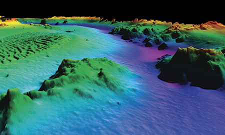
Bathymetry

Hydrographic Survey

Hydrographic-survey

We conduct surveys on Land, Swamps and Offshore using latest technologies. Various levels of expertise are available in Geodesy, Hydrographic Surveying, TOPOGRAPHICAL, Underwater Engineering, Geophysics and Computer services.

Our clients include; Oil and Gas Companies and Oil and Gas Service Companies, Dredging Companies, Utility Companies, Government agencies, Planners, Engineering Contractors and Individuals involved in making decision regarding the use of land and environmental resources, depending on complete and accurate survey data.

Let's get in touch

Send us an email and We'll get back to you, as soon as possible.

Send Message

Social Handles

Find us here

  • SSEL
  • Sesco Survey and Engineering Ltd
  • No, 3 Nyokuru Close, off Estate Road, Rumuogba, Port Harcourt, River State.
  • +2348056652127 | +2348068483703
  • sescosurvey.eng@gmail.com
  • https://sescosurveyandengineeringltd.com

Our Services

  • Comprehensive Surveying Services
  • Geotechnical Survey
  • Construction Support Services
  • Geophysical/Hydrographic Survey Services

Services

environmental-monitoring

construction-support-services

© 2025 · sescosurveyandengineeringltd.com                                  Designed by: greeninnova.com

  • Home
  • FAQ
  • Contact
  • Request a Call